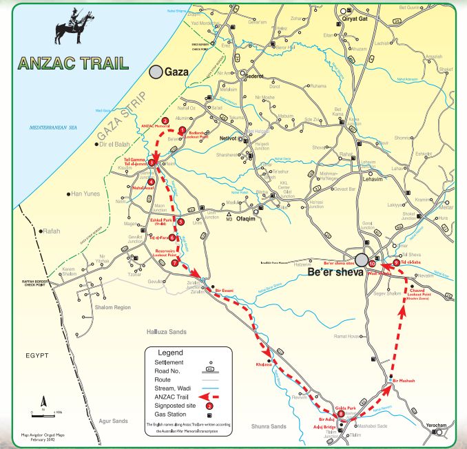
With thanks to www.israeltrade.org.au and the Jewish National Fund — Keren Kayemet LeYisrael for their work on the ANZAC-Trail-Brochure.pdf, which was the source of this map. It shows the ANZAC trail, preparing for a one day assault that took six months of planning.
The map shows the placement of Bir Essani, as Brigadier Grant said to his men, the closest water "this side of Beersheba". By visualizing the rolled barbed wire fortifications running in a line from Gaza to Beersheba, the three issues facing the British and the ANZACS who had lined up in front of those fortifications on that day, October 31st 1917, were
- There had to be no warning of an impending attack to the 4000 German and Turkish troops guarding Beersheba and its neighborhood prior to the day, else additional re-enforcements coming down north of the line could well have arrived in time to nullify that one day attack.
- The actual town itself had to be taken swiftly (by using mounted troops) to prevent the defenders from blowing up the wells upon seeing themselves facing imminent defeat. If the British had delayed the attack for the following morning, besides the problems of thirst, there were two distinct possibilities: either the Turks would be quite ready, resulting in probable failure, or all the wells would be blown, again, definite failure. By attacking suddenly very late in the day, and succeeding within one hour of the assault, the Aussies ensured that 15 of the 17 wells were saved.
- Failure for the 50,000 troops that were depending on them on that one day, would have meant humiliating retreat, forcing everyone back to wells at Bir Asluj, Bir Essani and others, confusion, sacrificing all gains. Yes, a "terrible fix" as Ion Idriess said later. Desperate times indeed.
Thank you Lord 
** End of page